Szerdán jön a lehülés, de addig kegyetlen kánikula lesz az országban
Akár 40 fok is lehet ma délután.

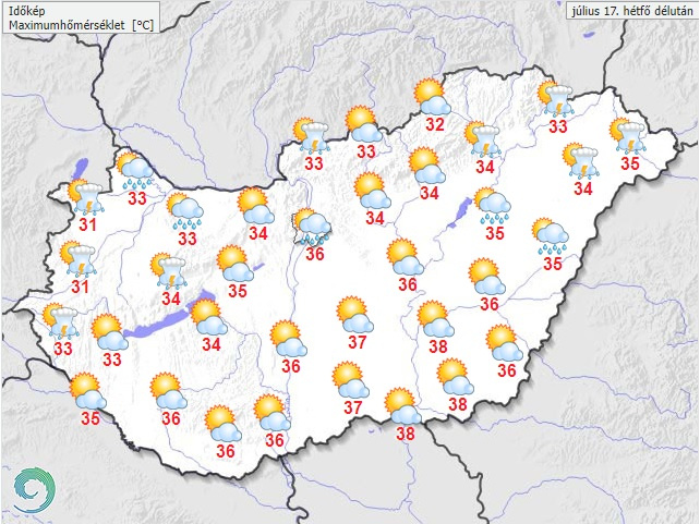
Tovább folytatódik a kánikula a jövő hét első felében, hétfőn a délkeleti országrészben a 39 Celsius-fok sem kizárt. Szerdától többfelé lehet zápor, zivatar, és kissé enyhül a hőség, a hét végén 26-32 fok várható a legmelegebb órákban – derül ki az Országos Meteorológiai Szolgálat országos, középtávú előrejelzéséből, amelyet vasárnap juttattak el az MTI-hez.
Hétfőn sok napsütésre kell számítani fátyol- és gomolyfelhők mellett. Főként az ország északi felén egy gyenge hidegfront miatt szórványosan lehetnek záporok, zivatarok, amelyeket akár felhőszakadás is kísérhet. A nyugatira, északnyugatira forduló szél megélénkül, zivatarok környezetében akár viharos lökések is előfordulhatnak.
A LEGMAGASABB NAPPALI HŐMÉRSÉKLET 31 ÉS 38 FOK KÖZÖTT VÁRHATÓ, DE DÉLKELETEN EGY-EGY HELYEN 39-40 FOK SEM KIZÁRT.
Fotó: Országos Meteorológiai Szolgálat
Kedden napos időre van kilátás, gomoly- és fátyolfelhőkkel. Általában száraz idő lesz, legfeljebb egy-egy zápor fordulhat elő. Többfelé megélénkül az északi, északnyugati szél. Hajnalban 16–23, délután 30–36 fok között alakul a hőmérséklet.
Szerdán viszont előbb meleg nedves szállítószalag, majd hidegfront alakítja a Kárpát-medence időjárását, így erőteljes gomolyfelhő-képződésre, illetve a fátyolfelhőzet mellett általában többórás napsütésre lehet számítani. Több helyen valószínű záporeső, zivatar, helyenként heves zivatar is kialakulhat. A déli, majd északnyugati szél néhol megerősödik, zivatarban viharos lökések is lehetnek. A minimum-hőmérséklet 14–22, a maximum 28 és 35 fok között várható, északkeleten mérhetik az alacsonyabb, a déli határvidéken a magasabb értékeket.
Csütörtökön sok napsütés várható, gomoly- és fátyolfelhőkkel. Helyenként kialakulhat záporeső, zivatar. Az északi, északnyugati szél néhol megélénkül, zivatarban megerősödhet. A hajnali 14–22 fokról 28 és 34 fok közé emelkedhet a hőmérséklet.
Pénteken erőteljes gomolyfelhő-képződésre és fátyolfelhőzetre is számítani lehet, több helyen előfordulhat záporeső, zivatar. A szél zivatar környezetében megerősödik. Hajnalban 14–22, délután 27–34 fok valószínű.
Szombaton erőteljes gomolyfelhő-képződés és fátyolfelhőzet mellett általában többórás napsütés valószínű. Több helyütt kialakulhat zápor, zivatar. Sokfelé megélénkül, helyenként megerősödik az északi, északnyugati szél, zivatarban viharos lökések is lehetnek. A minimum-hőmérséklet 15–22, a maximum 26 és 32 fok között várható.
Vasárnap a gomoly- és fátyolfelhők mellett általában sok napsütésre van kilátás, csak elszórtan valószínű záporeső, illetve zivatar. A szél csak zivatar térségében erősödhet meg. A hőmérséklet a hajnali 14–20 fokról 26 és 32 fok közé emelkedik.